This post contains affiliate links. As an Amazon Associate I earn from qualifying purchases
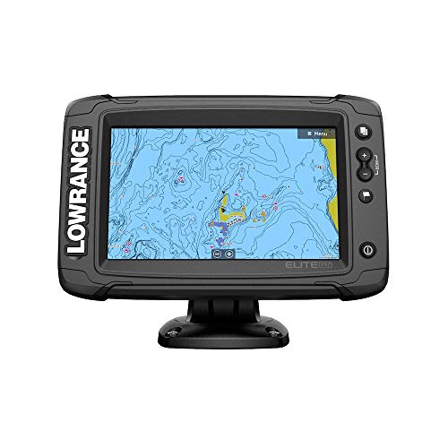
Elite-7 Ti² US Inland, HDI Transducer
Featuring support for Active Imaging, FishReveal and built-in US Inland charts and Genesis Live onscreen mapping, the Elite-7 Ti2 fishfinder/chartplotter is big enough for use as standalone display, but has a small enough footprint to be a perfect fit for boats with limited console space.
NEW Active Imaging
Perfect for pinpointing fish-holding areas like rockpiles, standing timber, weedbeds, ditches and drop-offs, It delivers the most superior clarity and the highest res. images of fish and structure at a longer range than any other structure-imaging technology
Wireless Networking
For the first time ever with the Elite series, you won’t need any cables to share sonar, mapping, waypoint and route data between Elite Ti2 displays
Mapping In Real-Time
Update the maps of your favorite fishing spot or map unmapped areas with 1/2 ft. contours in real time with C-MAP Genesis Live. Genesis Live uses digital depth to create high-def maps featuring 1/2ft. contours. This level of detail makes it easy to find areas where fish like to hide, like drop-offs, points, and ditches. It gives you control over contour transparency, contour density, depth and safety shading color palettes, and more. Create your Genesis Live maps in real-time, saving them to a microSD card
Preloaded High-Detail Mapping
Preloaded US Inland mapping featuring 4,000 lakes with 1ft. contours. The built-in map helps you narrow your search for productive water by making it easier to locate fishing hot spots like ledges, drop offs and cover
C-MAP Easy Routing and Navionics Dock-to-Dock Autorouting
Navigate faster and easier with automatic route planning. This menu-activated feature automatically plots the shortest and safest course based on a boat’s draft, beam and height, creating a route around a landmass, shoals and other fixed navigational hazards. Requires C-MAP MAX-N+ charts, Nav+ or Navionics Platinum charts
Product Features
- 7″ high-resolution Easy-to-use SolarMAX LED touchscreen display. Quick Access Control Bar provides one-touch access to system controls. Enhanced Surface Clarity lets you see more fish targets near the surface. 3000 Waypoints, 100 Routes, 100 Trails with up to 10,000 points per trail
- Preloaded C-MAP US Inland mapping with 1-foot contours on 4,000 lakes, plus a multitude of mapping options, including C-MAP, Navionics and more. C-MAP Genesis Live. C-MAP Easy Routing, Navionics Autorouting capability.
- Includes HDI transducer with Lowrance CHIRP and DownScan Imaging. Active Imaging 3-in-1 Sonar (CHIRP/Side/Down) Ready optional transducer required 000-14489-001 | Active Imaging 2-in-1 Sonar (Side/Down) Ready optional transducer. FishReveal Smart Target View. Smartphone Notifications. Wireless Networking. Integrated wireless connectivity. SmartSteer control for Xi5 Trolling Motor.
- Built-in CHIRP and Broadband Sounder. WiFI. Integrated Bluetooth. Supports 1 micro SD card up to 32GB. 1x Micro-C NMEA Port. 1 Virtual Ethernet Port. NMEA 2000 engine support. SonicHub2 compatible
- Package Includes – Elite-7 Ti² Fishfinder, Transom/Trolling Motor-mounted – 455 kHz/800 kHz DownScan Transducer, Suncover, Quick Release Bracket, Power Cable. 1 Year Warranty with Option to Upgrade to Five-Year Warranty Program. IPx6 and IPx7 Certified
Audible Annual Paid Membership
Gift of Audible 12-month Membership Plan
Kindle Unlimited 24 Month Paid Membership
Audible PLUS Paid Digital Membership
Gift of Audible 3-month Membership Plan
Gift of Audible 6-month Membership Plan
Gift of Audible 1-month Membership Plan
Kindle Unlimited 12 Month Paid Membership
SNAP EBT Enrollment
Audible PLUS Free Trial Digital Membership
The Drop Text Alerts
Kindle Unlimited 6 Month Paid Membership
Amazon Prime for Young Adults 6-month Trial
Amazon Baby Registry
Amazon Wedding Registry
Amazon Prime Free Trial
Kindle Unlimited Free Trial
Amazon Home Services
Prime Gaming
Amazon Prime Discounted Monthly Offering
Amazon Kids+ Free Trial
Amazon Kids+ Special Promotions
Prime Try Before You Buy First Box Checkout
Amazon Music Unlimited Monthly Subscription
Amazon Music Unlimited Digital Bundle
Amazon Prime Video Free Trial
This post contains affiliate links. As an Amazon Associate I earn from qualifying purchases